DanTDBV
Member
Does not work anymore!
The download site has been removed and been replaced with something, that I have yet to understand how to use.
It is still possible to go to the http://miljoegis.mim.dk/cbkort site and view Ortho photos across the ages.
I have used this with Greenshoot to get earlier Ortho photos piece by piece.
Happy Racing
There are multiple types of data, helpful to the trackbuilder available from the Danish government.
Such as DHM (The Danish Height model) and Orthophotos (airplane photos). DHM consists of LIDAR, that is LAS pointclouds compressed into LAZ files, different kinds of ASC surface models and large GEOTIFF images.
I will do another tutorial on getting the Orthophotos to keep this tidy.
The Danish data is downloadable from here:
http://download.kortforsyningen.dk/
The requirements for using the data, is to at someplace mention the name of the dataset, the download date and where it comes from.
I use this:
Copyright notice Padborg Park Point cloud and Ortho photo
As required, according to this site: (In Danish)
http://download.kortforsyningen.dk/content/vilk%C3%A5r-og-betingelser
Contains data from Geodatastyrelsen and Danske kommuner Fot-data
Ekstracted lokation : Padborg Park
DHM/Point cloud
DLD 24/3-2016 punktsky_607_51_LAZ_UTM32-ETRS89.zip
DLD 24/3-2016 punktsky_608_51_LAZ_UTM32-ETRS89.zip
http://download.kortforsyningen.dk/content/geodataprodukter
DLD = Download date
DanTDBV D@nN (My photo and film signature)
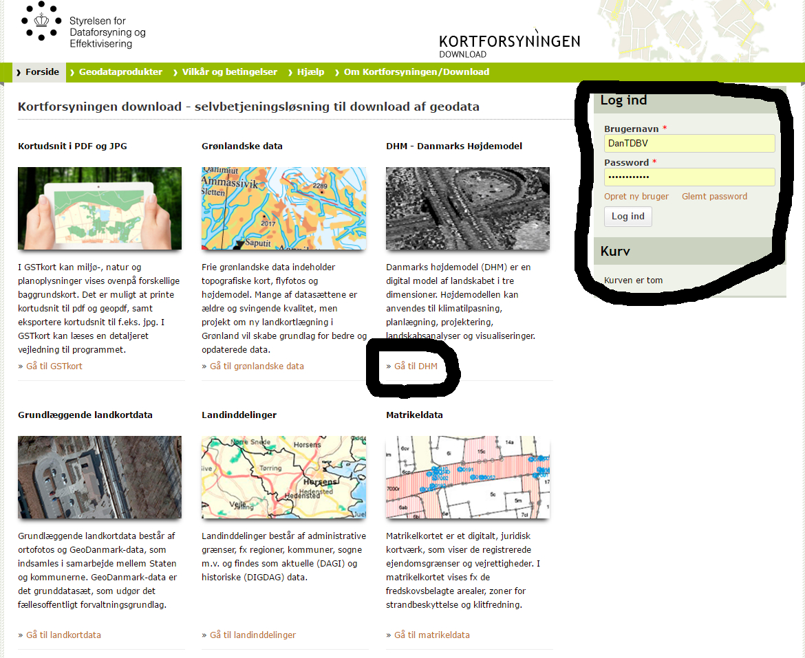
You need to register before you can download anything.
If in doubt post a screenshot and I will help you out.
You do NOT! Need to logged in, to browse around in the data.
For LIDAR data
Click Gå til DHM link DHM = Danmarks HøjdeModel = Denmarks Height Model
The different links sends you to a page, with a description you can copy to translate.
Current dataset with trees and buildings is DHM/Punktsky
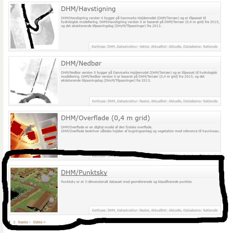
http://download.kortforsyningen.dk/content/dhmpunktsky
The looking glass is a search function you can use in all 3 steps. You can search for streetnames and places. You can even find the permanent Danish racing tracks. (Hint! Motorbane is a racingtrack).
In step 1 and 2 you can leftclick and drag the map around and zoom with the scrollwheel.
I am downloading Padborg Park in this session.
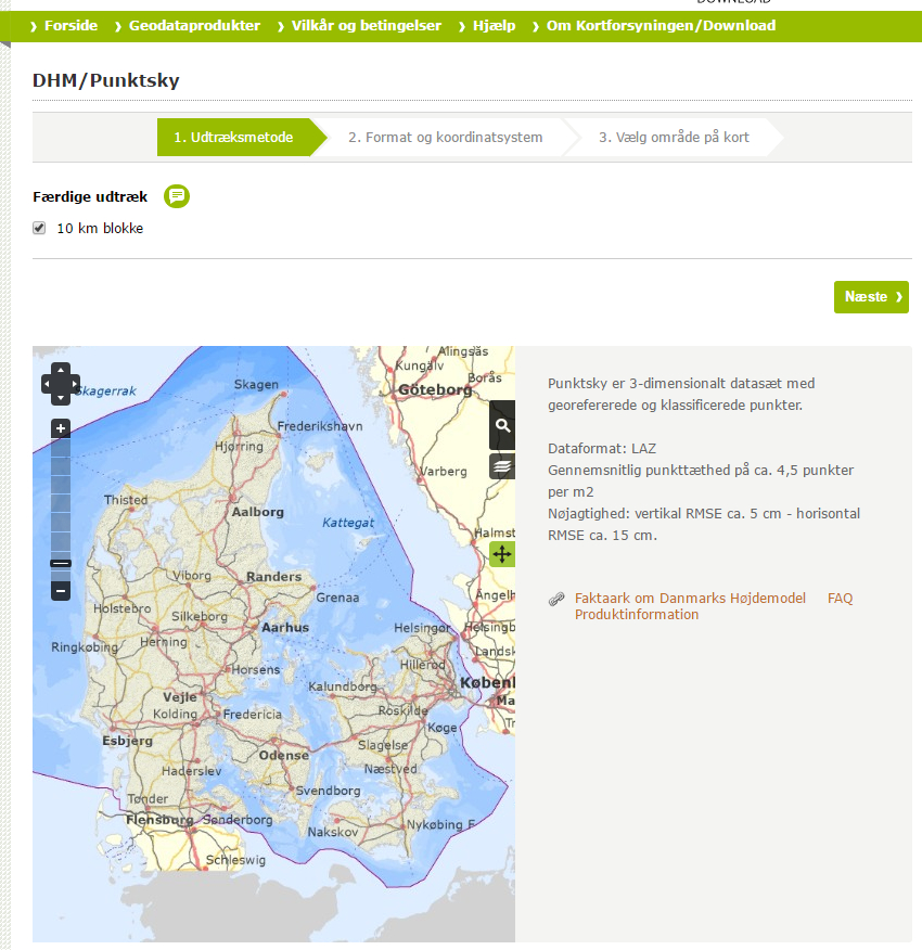
1. Udtræksmetode
V 10 km blokke, is saying that each selection, is a 10 km square. In some of the sections, you can select smaller chunks. It is a new function and I have not tried it yet.
Use the map to find the area you are interested in.
When you can see the desired area Click Næste
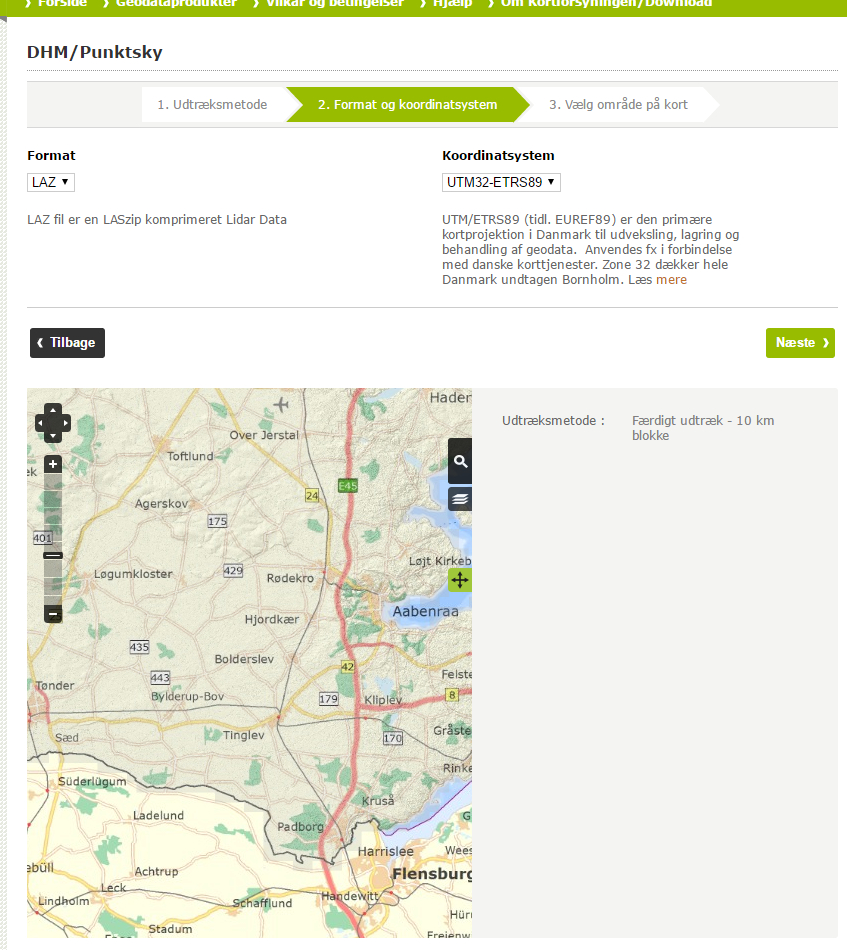
2. Format og koordinatsystem
Format (Chose file format)
Koordinatsystem (Chose coordinate system)
If you don't get any choises, click Næste
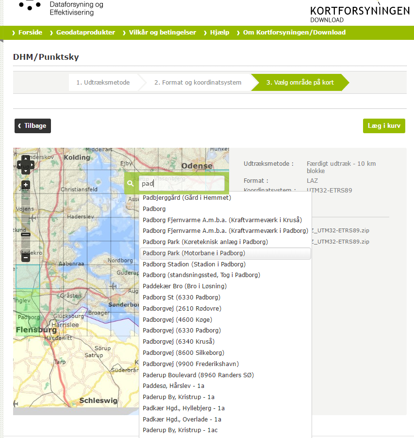
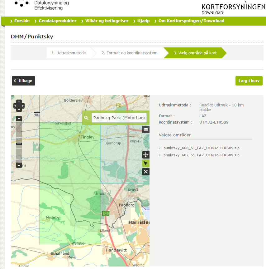
3. Vælg område på kort
Click on the areas that you need
You multiselect by clicking the next area.
Selected datasets show up in the sidebox.
Click again to deselect.
If you cannot select anything, then it means there are no data, for that area yet.
You can skip step 1 and 2, if you know that selection, format and coordinate system is to your liking and do your search in step 3.
When you have chosen what you need:
Click Læg i kurv
You get a list with the filesets you have selected
punktsky_607_51_LAZ_UTM32-ETRS89.zip
punktsky_608_51_LAZ_UTM32-ETRS89.zip
Click Gennemfør bestillingen
Log in (When you have logged in once and have asked you browser to remember you, you just need to click on fortsæt to log in.)
Click downloade din ordrer her
Rightclick and Save as
I chose to add the name of the area, I want to extract from the files and the downloaddate.
Padborg Park 24032016 punktsky_607_51_LAZ_UTM32-ETRS89.zip
Padborg Park 24032016 punktsky_608_51_LAZ_UTM32-ETRS89.zip
Each zip file contains a number of 1km square laz files. To find which files to use we go to:
http://miljoegis.mim.dk/cbkort?
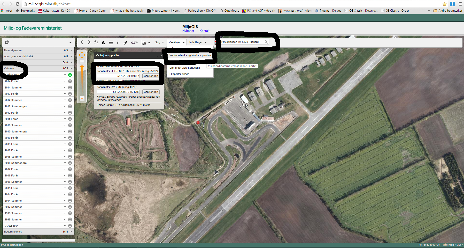
Enter the name of your area in the search field.
In some cases like Nisseringen and Jyllandsringen, that is enough.
In others like Padborg park, you will need to find the adress, for the place or one close to it.
The adress for Padborg Park is Flyvepladsen 10, 6330 Padborg
Click Ortofoto in the left collum
Click the buttons on the right side until the map turns into an airphoto
Click Værktøjer/Chose Vis Koordinater og lokaliser position
Now click on the 4 corners of the area that you are working with in turn and look at the coordinates you get here:
Koordinater i ETRS89 /UTM zone 32N
For Padborg Park it is roughfly
517629.33 6080487.64
517951.73 6080507.64
517343.73 6079933.24
517602.13 6079852.44
Our real interest here is the underlined numbers, it teels us the files to use.
PUNKTSKY_1km_6080_517.laz from set punktsky_608_51_LAZ_UTM32-ETRS89.zip
PUNKTSKY_1km_6079_517.laz from set punktsky_607_51_LAZ_UTM32-ETRS89.zip
In this case it is 2 files.
This should be enough to get you going.
If you have any questions please ask and I will try my best to answer.
Happy track building.
The download site has been removed and been replaced with something, that I have yet to understand how to use.
It is still possible to go to the http://miljoegis.mim.dk/cbkort site and view Ortho photos across the ages.
I have used this with Greenshoot to get earlier Ortho photos piece by piece.
Happy Racing
There are multiple types of data, helpful to the trackbuilder available from the Danish government.
Such as DHM (The Danish Height model) and Orthophotos (airplane photos). DHM consists of LIDAR, that is LAS pointclouds compressed into LAZ files, different kinds of ASC surface models and large GEOTIFF images.
I will do another tutorial on getting the Orthophotos to keep this tidy.
The Danish data is downloadable from here:
http://download.kortforsyningen.dk/
The requirements for using the data, is to at someplace mention the name of the dataset, the download date and where it comes from.
I use this:
Copyright notice Padborg Park Point cloud and Ortho photo
As required, according to this site: (In Danish)
http://download.kortforsyningen.dk/content/vilk%C3%A5r-og-betingelser
Contains data from Geodatastyrelsen and Danske kommuner Fot-data
Ekstracted lokation : Padborg Park
DHM/Point cloud
DLD 24/3-2016 punktsky_607_51_LAZ_UTM32-ETRS89.zip
DLD 24/3-2016 punktsky_608_51_LAZ_UTM32-ETRS89.zip
http://download.kortforsyningen.dk/content/geodataprodukter
DLD = Download date
DanTDBV D@nN (My photo and film signature)
You need to register before you can download anything.
- In the Log ind box chose Opret ny bruger
- Enter your information in the relevant boxes
- You only need to check the top checkbox.
- Click Opret ny bruger
If in doubt post a screenshot and I will help you out.
You do NOT! Need to logged in, to browse around in the data.
For LIDAR data
Click Gå til DHM link DHM = Danmarks HøjdeModel = Denmarks Height Model
The different links sends you to a page, with a description you can copy to translate.
Current dataset with trees and buildings is DHM/Punktsky
http://download.kortforsyningen.dk/content/dhmpunktsky
The looking glass is a search function you can use in all 3 steps. You can search for streetnames and places. You can even find the permanent Danish racing tracks. (Hint! Motorbane is a racingtrack).
In step 1 and 2 you can leftclick and drag the map around and zoom with the scrollwheel.
I am downloading Padborg Park in this session.
1. Udtræksmetode
V 10 km blokke, is saying that each selection, is a 10 km square. In some of the sections, you can select smaller chunks. It is a new function and I have not tried it yet.
Use the map to find the area you are interested in.
When you can see the desired area Click Næste
2. Format og koordinatsystem
Format (Chose file format)
Koordinatsystem (Chose coordinate system)
If you don't get any choises, click Næste
3. Vælg område på kort
Click on the areas that you need
You multiselect by clicking the next area.
Selected datasets show up in the sidebox.
Click again to deselect.
If you cannot select anything, then it means there are no data, for that area yet.
You can skip step 1 and 2, if you know that selection, format and coordinate system is to your liking and do your search in step 3.
When you have chosen what you need:
Click Læg i kurv
You get a list with the filesets you have selected
punktsky_607_51_LAZ_UTM32-ETRS89.zip
punktsky_608_51_LAZ_UTM32-ETRS89.zip
Click Gennemfør bestillingen
Log in (When you have logged in once and have asked you browser to remember you, you just need to click on fortsæt to log in.)
Click downloade din ordrer her
Rightclick and Save as
I chose to add the name of the area, I want to extract from the files and the downloaddate.
Padborg Park 24032016 punktsky_607_51_LAZ_UTM32-ETRS89.zip
Padborg Park 24032016 punktsky_608_51_LAZ_UTM32-ETRS89.zip
Each zip file contains a number of 1km square laz files. To find which files to use we go to:
http://miljoegis.mim.dk/cbkort?
Enter the name of your area in the search field.
In some cases like Nisseringen and Jyllandsringen, that is enough.
In others like Padborg park, you will need to find the adress, for the place or one close to it.
The adress for Padborg Park is Flyvepladsen 10, 6330 Padborg
Click Ortofoto in the left collum
Click the buttons on the right side until the map turns into an airphoto
Click Værktøjer/Chose Vis Koordinater og lokaliser position
Now click on the 4 corners of the area that you are working with in turn and look at the coordinates you get here:
Koordinater i ETRS89 /UTM zone 32N
For Padborg Park it is roughfly
517629.33 6080487.64
517951.73 6080507.64
517343.73 6079933.24
517602.13 6079852.44
Our real interest here is the underlined numbers, it teels us the files to use.
PUNKTSKY_1km_6080_517.laz from set punktsky_608_51_LAZ_UTM32-ETRS89.zip
PUNKTSKY_1km_6079_517.laz from set punktsky_607_51_LAZ_UTM32-ETRS89.zip
In this case it is 2 files.
This should be enough to get you going.
If you have any questions please ask and I will try my best to answer.
Happy track building.
Last edited:
