Accurate Elevations for France ?
- Thread starter r@m
- Start date
Mr Whippy
Active Member
I'm fairly sure Google have 3D maps (from aerial photogrammetry) for Paris.
I know Apple maps does.
So you can grab that data via re-photogrammetry technique.
I did that for the Italian Wall City track irSidanco (sp?) built a few years back for AC.
I could do something similar for you if you'd like?
Cheers
Dave
I know Apple maps does.
So you can grab that data via re-photogrammetry technique.
I did that for the Italian Wall City track irSidanco (sp?) built a few years back for AC.
I could do something similar for you if you'd like?
Cheers
Dave
Pixelchaser
Well-Known Member
earlier, I was like, what is this new found devilry ??? ends up watching same video.
but ! isn't this like using ninja ripper with google earth.
but ! isn't this like using ninja ripper with google earth.
r@m
Active Member
I was gobsmacked as well, if that process can be done for the entire course with elevations I'd be mighty impressed, it's definitely got my interest, It will have more when my hangover wears off.
re ninja ripper, I've had limited success using intruder inject with GE 7 on the photoreal layer, but mostly textures and garbled meshes, nothing usable.
re ninja ripper, I've had limited success using intruder inject with GE 7 on the photoreal layer, but mostly textures and garbled meshes, nothing usable.
Pixelchaser
Well-Known Member
to me and ive dabbled in many techniques, it looks all like a crock of shit to me. not for us track makers. whippy`s wall I understand, ive seen that, its striking! and in the context of a building alone but asides that this stuff is more useless than race track builder. the base data is what the problem is I think. I also think it could work with drone surveys not imperfect satellite data.
Last edited:
Pixelchaser
Well-Known Member
em if ninja ripper works, its easy and convenient, but you cant actually use any of this stuff practically in an efficient way for ac or any other sim. you still must make the mesh separately for game and at the end of the day its a fancy virtual tape measure for your eye balls.
Mr Whippy
Active Member
That's basically it yeah, just photogrammetry.Is this the method ?
It's hard to get really nice results very close to original quality, shooting in 4k+ and forcing Google to show best quality mesh and textures etc etc.
Plus original is lossy up close, so these 2nd hand versions are lossy again.
But they work nicely. I use them for any city track if I can.
I pitched for three city tracks this year (didn't get the work though sadly) and I collected this type of 2nd hand photogrammetry data plus aerial lidar, and the point clouds from this method and aerial lidar gave just as useful final results for general track topology.
In detail they're both noisy, so which data you trust more is up to you haha, but I'd say photogrammetry like this is as good as anything except static scanning or 1st hand hq aerial photogrammetry.
Another issue is scaling and orientation.
Then meshing, you can lose details there from the point cloud.
I'd say it's a good 7-8hrs start to finish for a big city track to get everything captured.
r@m
Active Member
How good are the elevations with this technique ? How do you keep the GE camera at a constant distance etc, seems ok in theory but a royal pain in the ass to do.
edit: nm got it. , shift and left right arrows, record tour, save tour as video, crop and save to frames , run through remake.
edit: nm got it. , shift and left right arrows, record tour, save tour as video, crop and save to frames , run through remake.
Last edited:
Mr Whippy
Active Member
I think you're under advertising it's usefulness.em if ninja ripper works, its easy and convenient, but you cant actually use any of this stuff practically in an efficient way for ac or any other sim. you still must make the mesh separately for game and at the end of the day its a fancy virtual tape measure for your eye balls.
It's a revolution for hobby and low budget pro by all accounts.
Having 3D reference material vs classically 2d top down and having to 'figure out' z data, often by doing lots of prototyping and test driving, going in circles for weeks 'tweaking' again and again.
And in the end it's just never right.
Been there, done that, under pressure. Time sink.
That's why laser scanning is even a thing.
Pay an artist or two for an entire year trying to 'guess' at it, or just pay £££ for laser and know it's spot on from day 1 of the build!
Mr Whippy
Active Member
That approach won't work very well in my experience.How good are the elevations with this technique ? How do you keep the GE camera at a constant distance etc, seems ok in theory but a royal pain in the ass to do.
edit: nm got it. , shift and left right arrows, record tour, save tour as video, crop and save to frames , run through remake.
Video is lossy.
You want 4k stuff, let each frame load up as any loading distorts image feature tracks or ultimately gives iffy data.
I've not used remake, but I assume it's straight to mesh, so more loss vs points, and you then have to align/scale it.
Give it a bash by all means but I'd do a lot of double checking your final results z data at multiple known points vs Google etc.
Ie verify what you get.
r@m
Active Member
Sure I'd love to see a good HD version, how about you just do a small section first and see how we go ?
I was intending on starting the route beginning soon, At Porte Dauphine, from the tunnel on Bd Periphierique up the off road that runs past Universite Paris-Dauphine and up to the roundabout at Place du Marechal.
How much can you grab in one go ?
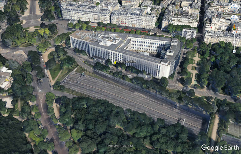
I was intending on starting the route beginning soon, At Porte Dauphine, from the tunnel on Bd Periphierique up the off road that runs past Universite Paris-Dauphine and up to the roundabout at Place du Marechal.
How much can you grab in one go ?
r@m
Active Member
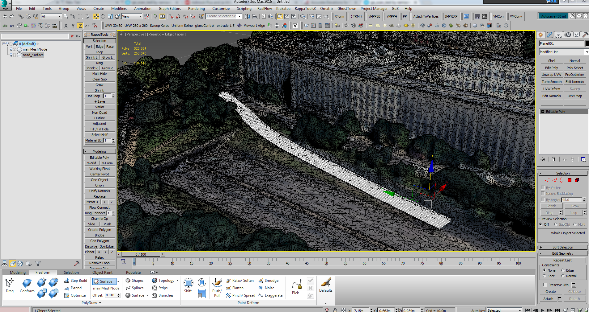
Had another little go, around 20 mins for the entire process, Mw Whippy I can see why you use this method  with hindsight I would have done this from the outset.
Elevations are so easy, I think the end result justifies the means to get it.
The only issue here as you say it matching up all the different scans, but even with 1080p images this is more than usable for pretty accurate elevations, and you could always do each scan separately and match up the elevated meshes.
I need to zoom in pretty close to the model at this resolution to get good results, 4k monitor and 1080ti on the shopping to-do list.
..hmm, no iframes here? not possible to embed sketchfab?
https://skfb.ly/6sr7H
with hindsight I would have done this from the outset.Elevations are so easy, I think the end result justifies the means to get it.
The only issue here as you say it matching up all the different scans, but even with 1080p images this is more than usable for pretty accurate elevations, and you could always do each scan separately and match up the elevated meshes.
I need to zoom in pretty close to the model at this resolution to get good results, 4k monitor and 1080ti on the shopping to-do list.
..hmm, no iframes here? not possible to embed sketchfab?
https://skfb.ly/6sr7H
Last edited:
